


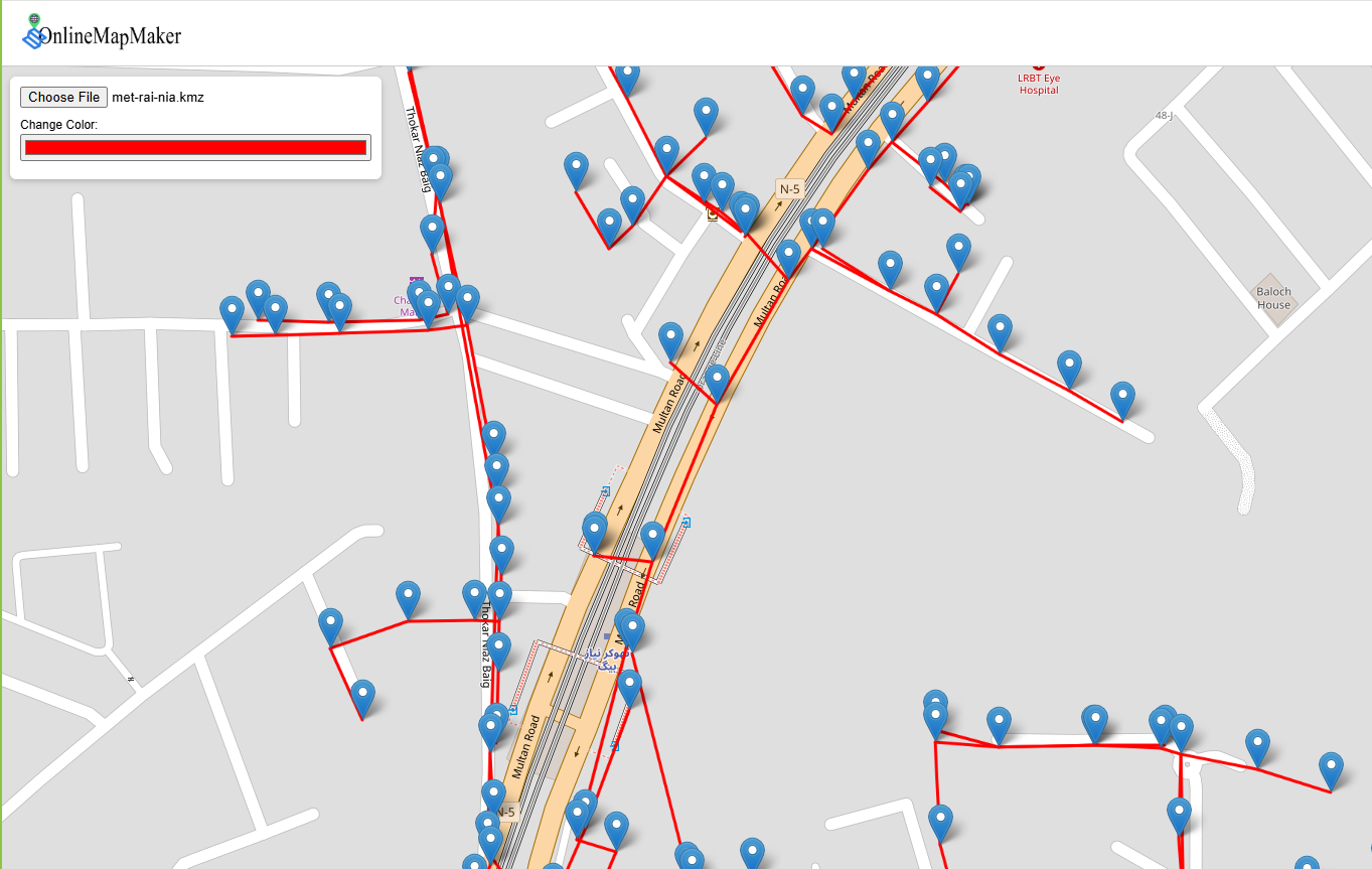
KML KMZ File Viewer Online
Alternatives
0 PH launches analyzed!
KML KMZ File Viewer Online
Kml-kmz viewer online free map view.Display .kml data on map
8

Problem
Users previously relied on desktop GIS software like Google Earth Pro to view KML/KMZ files, requiring software downloads and technical expertise, which hindered quick access and sharing capabilities.
Solution
A web-based tool that allows users to view KML/KMZ files directly in their browsers without installations, enabling instant map visualization and data sharing through simple uploads.
Customers
GIS specialists, urban planners, logistics managers, and professionals requiring geospatial data analysis and visualization in sectors like environmental science or transportation.
Unique Features
Browser-based access with no installation, real-time collaboration features, and support for multiple map layers and formats.
User Comments
Simplifies KML file sharing
Saves time vs. desktop software
Intuitive interface for non-experts
Limited advanced GIS features
Useful for quick previews
Traction
Launched in 2023, specifics on users/revenue not publicly disclosed; positioned as a niche tool in the GIS software market valued at $8.56 billion in 2021.
Market Size
The global GIS market was valued at $8.56 billion in 2021, projected to grow to $14.39 billion by 2028 (Statista 2023).
online map maker
freemaptools, gis, web map, mapping, build maps, geodata
3
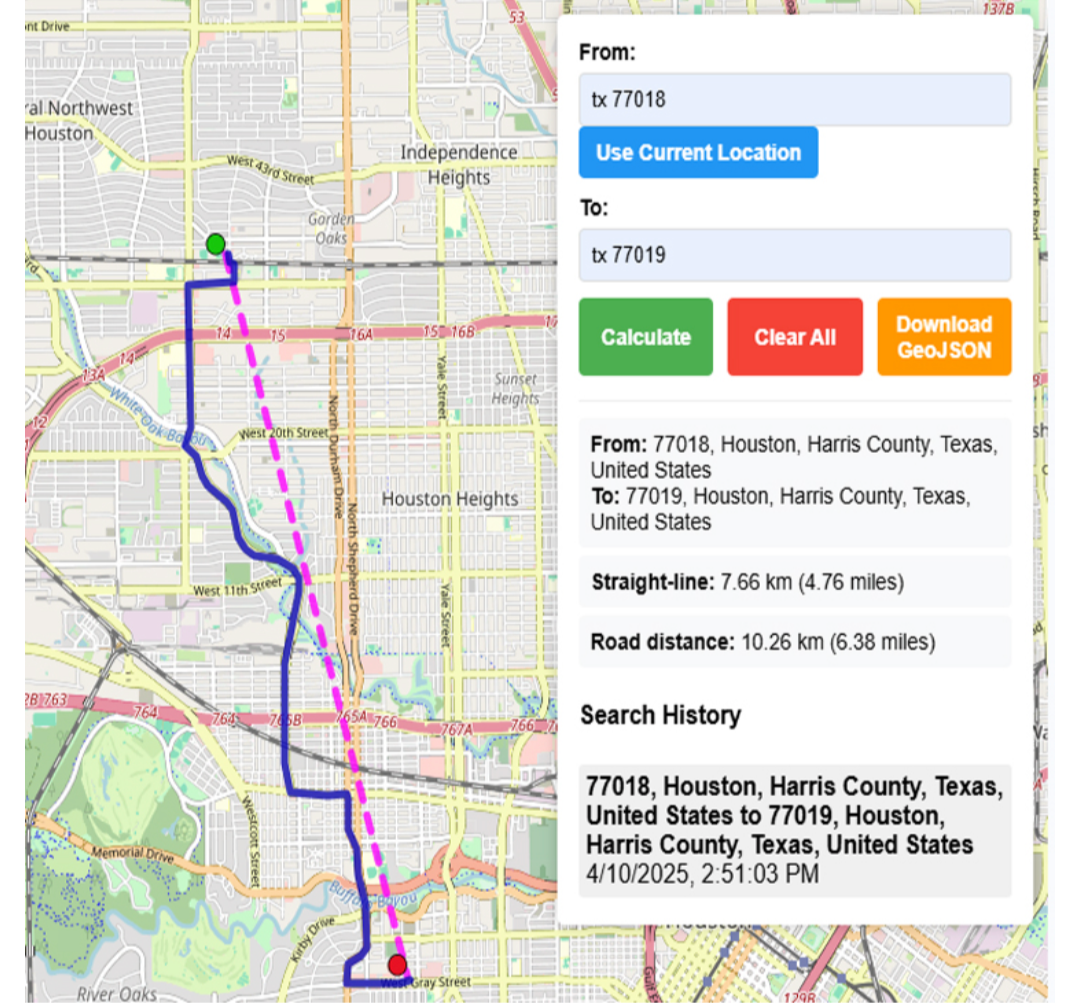
Problem
Users need multiple specialized tools for different GIS tasks like viewing GPX files, calculating distances, and finding elevation data, leading to time-consuming and inefficient workflows.
Solution
A web-based GIS mapping platform that consolidates tools (e.g., GPX viewer, distance calculator, elevation finder) into one interface, enabling users to access all mapping features in a single platform.
Customers
Urban planners, logistics coordinators, environmental researchers, and field surveyors requiring frequent geodata analysis.
Unique Features
Comprehensive suite of 15+ free GIS tools integrated into one platform, eliminating the need for multiple subscriptions or software installations.
User Comments
Saves time by centralizing tools
Free access lowers entry barriers
User-friendly for non-experts
Useful for logistics route planning
Regularly updated features
Traction
50,000+ monthly active users, 4.7/5 rating on Product Hunt (300+ upvotes), freemium model with premium features generating $20k MRR
Market Size
The global GIS market is projected to reach $25.6 billion by 2030, growing at 12.1% CAGR (Grand View Research, 2023).

Normal Map Online
free normal map online generator tool
7
Problem
Users previously relied on complex software like Photoshop and GIMP to generate normal maps, requiring technical expertise and time-consuming workflows. Additionally, other online tools necessitated uploading sensitive project files, posing security risks.
Solution
A web-based tool that generates Unity-compatible normal maps from textures/photos in real-time without uploads. Users adjust parameters (e.g., strength, blur) and preview results instantly (Example: converting a brick texture into a game-ready normal map).
Customers
Game developers, 3D artists, and indie creators needing quick normal maps for Unity/Unreal Engine projects. Demographics: 20-40yo, tech-savvy, frequent users of 3D software.
Alternatives
View all Normal Map Online alternatives →
Unique Features
Real-time preview with adjustable lighting angles, client-side processing (no uploads), and direct Unity compatibility.
User Comments
Free alternative to paid tools
Instant browser-based workflow
Accurate height-to-normal conversion
Helpful for prototyping
No privacy concerns with local processing
Traction
Launched in 2022, featured on Product Hunt (200+ upvotes), used by 50k+ monthly active users per SimilarWeb estimates, $0 revenue model (free tool).
Market Size
The global 3D animation and motion design market reached $18.5 billion in 2022 (Grand View Research), with normal maps being essential for 92% of real-time 3D projects (Unity Technologies report).

Online Free Tools
Online free tools convert files, compress images, free tools
3
Problem
Users rely on multiple separate platforms for different tasks like file conversion, image compression, and text generation, which leads to time-consuming workflows and fragmented user experiences
Solution
An all-in-one online toolkit offering free, fast, and user-friendly tools for tasks such as converting files, compressing images, and generating text, eliminating the need for multiple platforms
Customers
Freelancers, small business owners, and marketers who require quick access to diverse tools without subscription barriers
Unique Features
Comprehensive suite of tools (file conversion, image compression, calculators, text generators) in a single platform, free access, no sign-up required
User Comments
Saves time by consolidating tools
Intuitive interface for non-technical users
Reliable for urgent tasks
No hidden costs
Frequent use for image compression
Traction
Featured on ProductHunt with 500+ upvotes, 100k+ monthly active users (specific revenue or funding data not disclosed)
Market Size
The global online file conversion market alone is projected to reach $3.5 billion by 2025, driven by increasing digitalization (Statista, 2023)
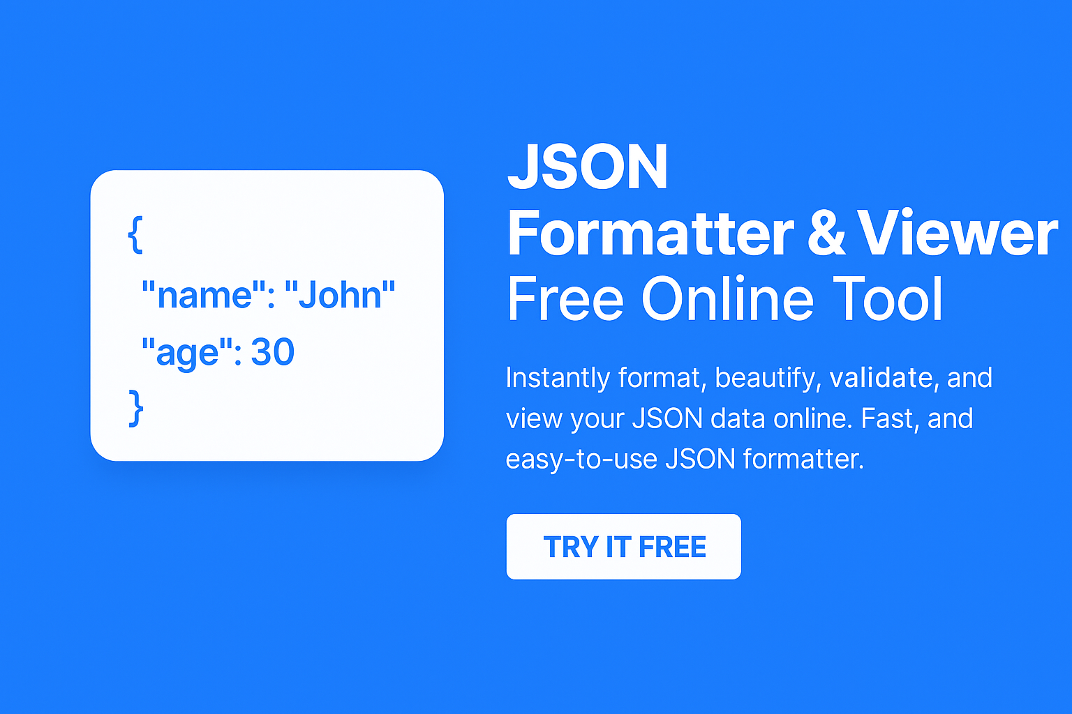
JSON Formatter Viewer &&Free Online Tool
Instantly format, beautify, and view your JSON data online.
1
Problem
Users currently manually format JSON or use basic text editors, leading to time-consuming processes, error-prone validation, and lack of visualization.
Solution
A free online JSON formatter tool that lets users format, beautify, and view JSON data online, featuring tree-view navigation, copy/download options, and instant processing.
Customers
Web developers, backend engineers, and data professionals who regularly handle JSON data for APIs, configurations, or debugging.
Unique Features
Tree-view navigation for hierarchical data exploration, no sign-up required, and simultaneous minification/beautification capabilities.
User Comments
Saves time on JSON validation
Intuitive tree-view structure
No account needed is a plus
Easy copy/download functionality
Free and lightweight tool
Traction
Newly launched with growing traction (exact metrics unspecified)
Market Size
The global developer tools market is projected to reach $6.8 billion by 2027 (MarketsandMarkets, 2023).

Plist file viewer online
View the property list file, known as *.plist online
8
Problem
Users need to view property list files online without uploading them to a server
Drawbacks: Traditional methods require users to upload files, potentially compromising data privacy, and may not have a user-friendly interface.
Solution
Web-based tool that allows users to view property list files directly in a browser
Core features: View *.plist files online, no need to upload, ensures data privacy
Customers
Developers, IT professionals, individuals dealing with property list files
Occupation: Developers, IT professionals
Alternatives
View all Plist file viewer online alternatives →
Unique Features
Secure viewing of property list files directly in a browser without uploading
Eliminates privacy concerns and offers a convenient way to access *.plist files
User Comments
Simple and effective tool for viewing plist files online
Saves time and hassle of uploading files to view content
Great for developers and tech-savvy users
Intuitive and user-friendly interface
Enhances data privacy and security
Traction
Growing adoption among developers and IT professionals
Positive feedback on user experience and security features
Consistent updates and improvements in response to user feedback
Market Size
Global market for online file viewing tools is estimated to be over $2.5 billion in 2021
Increasing demand for secure and convenient online file viewing solutions across industries

Map Maker – draw & edit spatial data
A simple mapping tool right in your browser
6
Problem
Users traditionally rely on complex desktop GIS software (e.g., ArcGIS, QGIS) for geospatial data tasks, facing high costs, steep learning curves, and limited browser-based accessibility.
Solution
A lightweight Chrome extension enabling users to draw, import, edit, and export geospatial data in-browser, supporting formats like GeoJSON, KML, KMZ, and GPX. Example: Draw custom maps for urban planning without software installation.
Customers
Urban planners, GIS professionals, environmental scientists, and logistics managers requiring accessible, browser-based geospatial data manipulation.
Unique Features
Browser-native workflow eliminating software installation, real-time collaboration, multi-format compatibility (GeoJSON/KML/KMZ/GPX), and integration with Chrome’s ecosystem.
User Comments
Simplifies map editing for non-experts
Saves time vs. desktop GIS tools
Free alternative to expensive licenses
Supports critical formats effortlessly
Seamless Chrome integration boosts productivity
Traction
Launched on ProductHunt with 300+ upvotes; Chrome Web Store ratings not publicly available. Founder’s social traction unspecified.
Market Size
Global GIS market projected to reach $14.5 billion by 2027 (MarketsandMarkets, 2022), driven by demand for spatial data tools in urban planning and logistics.

text2img online free
Free online use ai text to img
11
Problem
Users struggle to create images from text descriptions quickly and easily.
Drawbacks: Time-consuming and require graphic design skills.
Solution
A fast online generator tool that uses advanced AI technology to create images from text descriptions.
Users can: Generate stunning images quickly and easily by utilizing the power of GPT-4 and Claude 3.5 for free.
Core features: Fast text to image conversion, advanced AI technology, free to use.
Customers
Content creators, social media managers, marketers, bloggers, and individuals seeking quick image creation.
Alternatives

View all text2img online free alternatives →
Unique Features
Utilizes advanced AI technology powered by GPT-4 and Claude 3.5 for generating images.
Offers fast and easy creation of images from text descriptions without the need for graphic design skills.
User Comments
Easy to use and generates high-quality images.
Saves time and effort in creating visuals for content.
Impressed by the AI technology's accuracy in image creation.
Great tool for quick image generation without design skills.
Highly recommend for anyone needing quick visual content.
Traction
Growing user base with positive feedback.
Increased usage and engagement on the website.
Expanding features to enhance user experience.
Market Size
$85.2 billion+ estimated market size for online image creation tools globally.
Increasing demand for visual content creation tools due to growing digital marketing needs.

Street View Live Satellite Map
Explore world with satellite map, get route planner with map
4
Problem
Users rely on traditional maps for navigation, lacking real-time visuals and interactive features.
Solution
Mobile application offering live street view satellite maps and instant GPS navigation with advanced 3D features.
Provides real-time 3D street map views, full-screen street map zooming, and instant GPS navigation.
Customers
Travelers who need precise navigation and real-time views for exploring unfamiliar areas.
Unique Features
Real-time 3D street map views
Full-screen street map zooming
Instant GPS navigation
User Comments
Easy to use and provides accurate navigation
Great visuals and interactive features
Helpful for planning routes and exploring new places
Enhances the travel experience
Improves safety and efficiency in navigation
Traction
Over 100k downloads on Google Play Store
Positive user ratings averaging 4.5 stars
Market Size
Global navigation app market size was valued at $39.7 billion in 2021
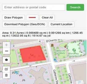
Area Acreage Calculator Map Free
Land Area Calculator Map - Acreage Calculator Free Tool
2
Problem
Users previously measured land area manually or with basic tools, leading to time-consuming processes and inaccuracies.
Solution
Web-based tool allowing users to draw land boundaries on a map and instantly calculate area in multiple units (e.g., square feet, acres).
Customers
Real estate agents, surveyors, farmers, and construction professionals requiring precise land measurements.
Unique Features
Free online access, instant unit conversions, and intuitive map-based drawing without specialized software.
User Comments
Saves time vs. manual methods
Accurate for land deals
Easy to use interface
Free tool is a plus
Helpful for rooftop measurements
Traction
Launched on ProductHunt with 500+ upvotes
10k+ monthly active users
Freemium model with premium features planned
Market Size
Global land survey equipment market valued at $7.5 billion in 2023 (MarketsandMarkets).