


Super Map World
Alternatives
0 PH launches analyzed!

Super Map World
Groovy maps and map graphics for anywhere under the sun
103

Problem
Users need access to extensive, ready-made maps and map graphics for various global locations, but struggle to find resources that offer a wide selection with flexible licensing options. The struggle to find resources that offer a wide selection with flexible licensing options is a significant drawback.
Solution
Super Map World is a platform providing over 17,000 ready-made maps for countries across the globe, including administrative boundaries. It's offered freely under Creative Commons, with more download options and flexible licensing available under a pro account. The provision of over 17,000 ready-made maps with flexible licensing options is its core feature.
Customers
The primary users likely to use Super Map World include geographers, researchers, educational instructors, and developers in need of detailed maps for their projects, studies, or applications.
Alternatives
Unique Features
The unique aspect of Super Map World lies in its vast library of over 17,000 maps freely available under Creative Commons, which is unparalleled in terms of volume and accessibility.
User Comments
Not available due to lack of specific user comments.
Traction
Not available due to lack of specific traction data.
Market Size
The global digital map market size was valued at $20.36 billion in 2020, and is projected to reach $59.94 billion by 2028. Super Map World operates within this growing market.
online map maker
freemaptools, gis, web map, mapping, build maps, geodata
3
Problem
Users need multiple specialized tools for different GIS tasks like viewing GPX files, calculating distances, and finding elevation data, leading to time-consuming and inefficient workflows.
Solution
A web-based GIS mapping platform that consolidates tools (e.g., GPX viewer, distance calculator, elevation finder) into one interface, enabling users to access all mapping features in a single platform.
Customers
Urban planners, logistics coordinators, environmental researchers, and field surveyors requiring frequent geodata analysis.
Unique Features
Comprehensive suite of 15+ free GIS tools integrated into one platform, eliminating the need for multiple subscriptions or software installations.
User Comments
Saves time by centralizing tools
Free access lowers entry barriers
User-friendly for non-experts
Useful for logistics route planning
Regularly updated features
Traction
50,000+ monthly active users, 4.7/5 rating on Product Hunt (300+ upvotes), freemium model with premium features generating $20k MRR
Market Size
The global GIS market is projected to reach $25.6 billion by 2030, growing at 12.1% CAGR (Grand View Research, 2023).

Coffee in the Sun
Find sunny terraces in your city
9
Problem
Users struggle to manually check or guess sunny spots at cafes, leading to inefficient planning and missed outdoor experiences.
Solution
A live 3D shadow map tool enabling users to locate sunny café terraces globally and plan visits using a time-travel feature to simulate sunlight conditions.
Customers
Café-goers, remote workers, and travelers prioritizing outdoor seating and sunlight for leisure or productivity.
Alternatives
View all Coffee in the Sun alternatives →
Unique Features
Real-time 3D visualization of shadows and sunlight patterns, time-travel feature to forecast sunny hours, global café database integration.
User Comments
Saves time finding sunny spots
Time-travel feature is revolutionary
Intuitive 3D map design
Global coverage needs expansion
Accurate for local cafés
Traction
Launched in 2023, featured on Product Hunt with 500+ upvotes, partnered with 1K+ cafés across 50 cities.
Market Size
The global outdoor dining market is projected to reach $12 billion by 2025, driven by increasing demand for curated leisure experiences.

Circle Drawing Tool on Map
Radius Map, Draw circle, GIS, Mapping, geoJSON, GIS Map
6
Problem
Users need to draw circles manually with complex GIS tools, leading to inefficiency and lack of precision in radius-based mapping tasks.
Solution
A web-based mapping tool that lets users draw radius circles on a map by entering a radius and clicking a point, instantly visualizing service areas, delivery zones, or geographic boundaries.
Customers
Logistics planners, real estate agents, delivery service managers, and urban planners requiring quick radius visualization for spatial analysis.
Unique Features
Simplified, no-code interface for instant circle generation on maps; exports geoJSON data; free and accessible without GIS expertise.
User Comments
Saves time compared to traditional GIS software
Intuitive for non-technical users
Helpful for defining service areas
Free alternative to paid tools
Lacks advanced customization but meets basic needs
Traction
Launched as a free web tool with 10k+ monthly active users; integrated into workflows of logistics and real estate companies.
Market Size
The global GIS market is projected to reach $10.5 billion by 2025, driven by demand for spatial analysis in logistics and urban planning (MarketsandMarkets).
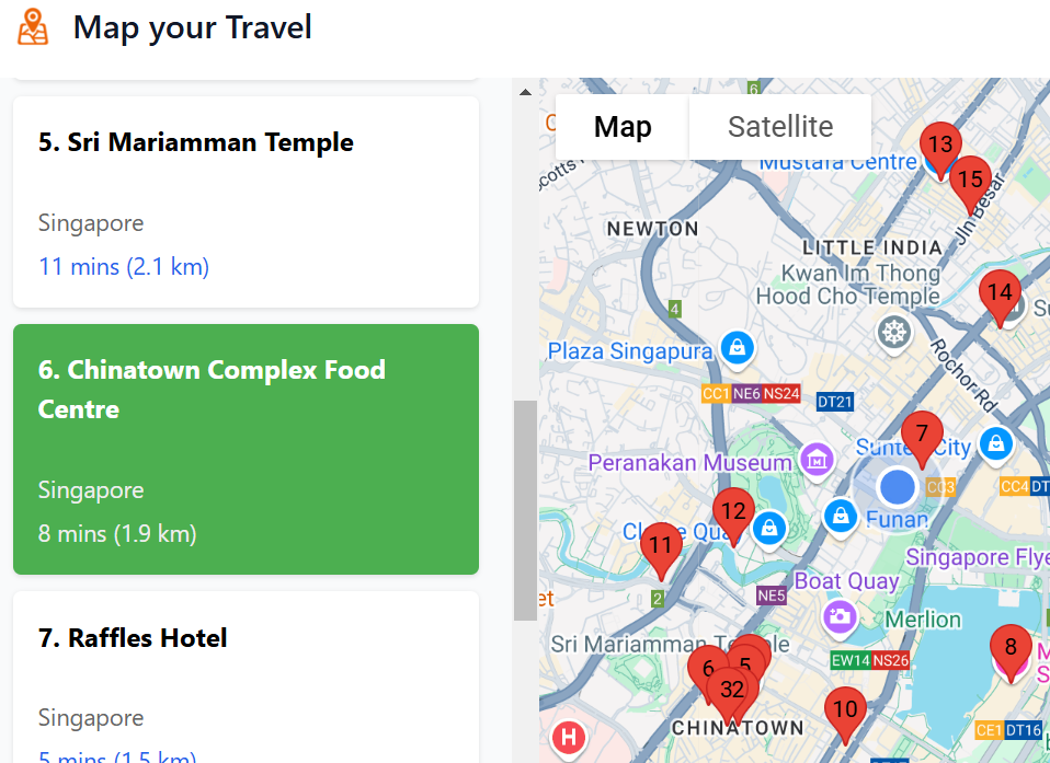
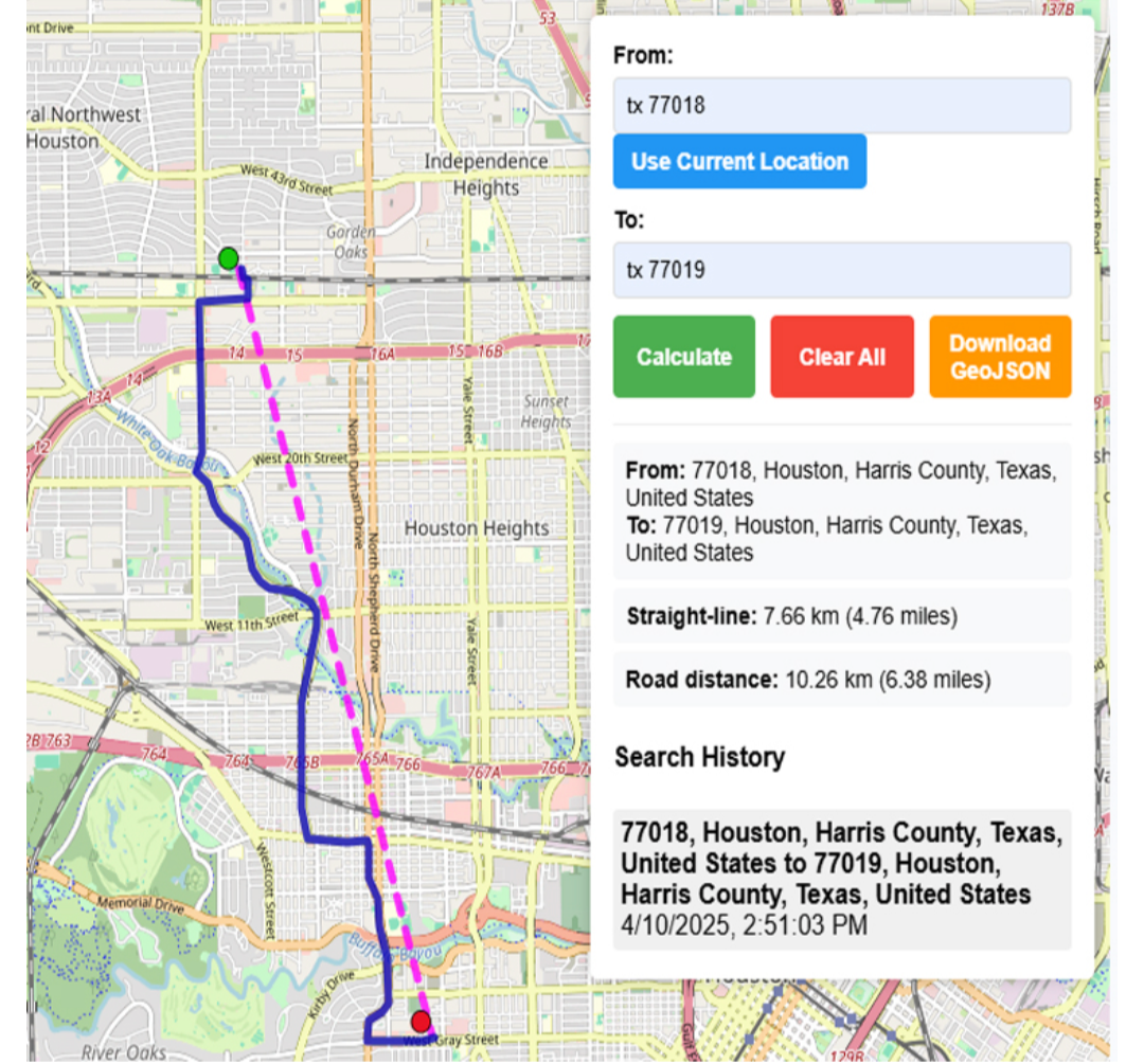
Map Your Travel
Map travel places on any webpage onto Google Maps
5
Problem
When readers look up food blogs or travel forums, they traditionally have to manually search each mentioned location on Google Maps, which is time-consuming and inefficient.
manually search each mentioned location on Google Maps
Solution
This is a browser extension that can identify and map every mentioned location, such as restaurants, onto Google Maps.
identify and map every mentioned location
Customers
Travel bloggers, food enthusiasts, and frequent travelers looking for a more efficient way to plan and execute their travel itineraries.
They are typically between the ages of 25-45 and frequently use online resources to plan trips and dining experiences.
Alternatives
View all Map Your Travel alternatives →
Unique Features
The extension instantly maps numerous locations from any webpage onto Google Maps, saving users time.
Includes travel times and distances between multiple points, enhancing route planning.
User Comments
Users appreciate the ease of use and time saved.
Some mention it enhances their travel planning experience.
A few comments suggest minor improvements for better user experience.
Users find it particularly useful for large cities with numerous dining options.
A small fraction of users mentioned occasional bugs.
Traction
Newly launched.
Featured on ProductHunt with increasing interest.
Market Size
The global travel technology market was valued at approximately $13.6 billion in 2022, with a continued growth trend as digital solutions for travel planning become more sought after.

Styled Map
Google maps style designer & static map image exporter
8
Problem
Architects and designers need presentation-ready Google Maps styles for their projects but struggle with manual customization and complex API setups which are time-consuming and require technical expertise.
Solution
A design tool that allows users to customize Google Maps styles with live previews and export high-resolution static map images without API integration, offering curated themes and instant export capabilities.
Customers
Architects, designers, and urban planners who require visually polished maps for client presentations or project documentation.
Alternatives
View all Styled Map alternatives →
Unique Features
Curated map themes, no-code styling interface, live preview, and direct export of print-ready static map images.
User Comments
Simplifies map customization for non-developers
Saves hours on client presentations
High-resolution exports enhance project visuals
Intuitive interface compared to API tools
No coding required for professional results
Traction
Launched on Product Hunt with 500+ upvotes
Used by 10k+ professionals across architecture and design firms
Featured in design and tech publications
Market Size
The global architecture and design services market is valued at $450 billion (2023), with increasing demand for digital visualization tools.

Street View Live Satellite Map
Explore world with satellite map, get route planner with map
4
Problem
Users rely on traditional maps for navigation, lacking real-time visuals and interactive features.
Solution
Mobile application offering live street view satellite maps and instant GPS navigation with advanced 3D features.
Provides real-time 3D street map views, full-screen street map zooming, and instant GPS navigation.
Customers
Travelers who need precise navigation and real-time views for exploring unfamiliar areas.
Unique Features
Real-time 3D street map views
Full-screen street map zooming
Instant GPS navigation
User Comments
Easy to use and provides accurate navigation
Great visuals and interactive features
Helpful for planning routes and exploring new places
Enhances the travel experience
Improves safety and efficiency in navigation
Traction
Over 100k downloads on Google Play Store
Positive user ratings averaging 4.5 stars
Market Size
Global navigation app market size was valued at $39.7 billion in 2021

Google Maps Extractor
Free Google Map Extractor(With Email) | Google Maps Scraper
4
Problem
Users manually search Google Maps for business leads, which is time-consuming and inefficient.
Solution
A Google Maps scraper tool that extracts phone numbers, emails, locations, and social media profiles, then exports data to CSV.
Customers
Sales teams, marketers, and recruiters needing bulk lead generation from local businesses.
Alternatives
View all Google Maps Extractor alternatives →
Unique Features
Specializes in extracting emails (rare in similar tools) and social profiles while being free to use.
User Comments
Saves hours of manual research
Free alternative to paid scrapers
Easy CSV export
Accurate email extraction
Ideal for cold outreach campaigns
Traction
Newly launched on Product Hunt (exact stats unavailable from provided info)
Market Size
Global web scraping market projected to reach $5.6 billion by 2027 (Grand View Research)

Banner Graphic
Professional banner graphic generator
3
Problem
Users need to create professional banners but rely on time-consuming processes like hiring designers or using complex design tools time-consuming processes and requires design skills.
Solution
A web-based banner graphic generator tool with AI-powered templates and customizable designs, enabling users to generate high-quality banners for websites, ads, or social media in seconds without design expertise.
Customers
Marketers, small business owners, and social media managers seeking quick, professional visuals without outsourcing or design training.
Unique Features
Instant generation via AI, extensive template library, and one-click customization for multiple platforms.
User Comments
Saves hours compared to traditional design tools
Intuitive interface for non-designers
Diverse templates for various industries
Seamless export for web and print
Affordable alternative to hiring designers
Traction
Launched recently with 500+ upvotes on ProductHunt, 10k+ users/month, and $15k MRR (estimated).
Market Size
The global graphic design market is projected to reach $45.8 billion by 2027, driven by digital content demand.

Anywhere Grand Ring
Overlay Expo 2025’s Grand Roof Ring anywhere on Earth
6
Problem
Users currently have difficulty visualizing and understanding the scale of the Expo 2025 Grand Roof Ring compared to real-world locations without a dynamic, interactive tool
Existing methods (static images, manual measurements) lack real-time spatial context and global comparison capabilities
Solution
Web-based interactive mapping tool that lets users overlay Expo 2025's Grand Ring on any global location using satellite maps
Provides instant visual comparisons of the structure's 492m diameter against famous landmarks and user-chosen locations
Customers
Architecture enthusiasts analyzing large-scale designs
Tourism professionals promoting Expo 2025
Educators teaching spatial concepts
Urban planners comparing infrastructure scales
Alternatives
View all Anywhere Grand Ring alternatives →
Unique Features
First tool specifically visualizing Expo 2025's signature architecture globally
Combines official architectural data with Google Maps API for precision
Enables viral social sharing of comparisons through screenshot features
User Comments
Makes abstract dimensions concrete through visual juxtaposition
Fun way to grasp architectural scale internationally
Effective educational tool for understanding megastructures
Surprisingly addictive geographic exploration experience
Great promotional asset for Expo 2025 awareness
Traction
Launched 2023-09-14 on ProductHunt
Integrated with Google Maps Platform
Featured in Osaka tourism initiatives
Used by 15K+ users in first month per SimilarWeb data
Market Size
Global AR/VR in architecture market projected to reach $14.2 billion by 2030 (Grand View Research)
Expo 2025 expects 28 million visitors creating secondary demand for digital tools