


OGMAP - Map Tiles API
Alternatives
0 PH launches analyzed!

OGMAP - Map Tiles API
Vector map tiles (pbf)
6

Problem
Users previously relied on expensive traditional map tile services with high costs and inflexible pricing models.
Solution
A vector map tiles API providing developers access to ultra-low-cost vector tiles (PBF format) via a prepaid auto-buy system through Stripe, such as $10 = 1,000,000 tiles and 250k free tiles on sign-up.
Customers
Developers and tech companies needing scalable, cost-effective mapping solutions for apps, navigation, or location-based services.
Unique Features
Ultra-low-cost pricing (0.01¢/tile), prepaid safety limits, Cloudflare CDN for fast global delivery, MapLibre integration, and a free tier.
User Comments
Affordable alternative to Mapbox/Google Maps
Easy integration with MapLibre
Transparent pricing model
Reliable CDN-backed delivery
Developer-friendly API documentation
Traction
Pricing starts at $10/month for 1M tiles; launched free tier with 250k tiles post-signup; prepaid auto-buy via Stripe and Cloudflare CDN support.
Market Size
The global geospatial services market is projected to reach $500 billion by 2030, driven by demand in logistics, urban planning, and IoT.

Vector Tile to Raster Tile
Vector tiles to raster tiles (iOS, Android, Windows) Basemap
6
Problem
Current users rely on basemaps available from online services or local tile layers for various platforms like iOS, Android, and Windows.
These solutions do not offer offline usability, causing challenges in austere and DDIL (Denied, Degraded, Intermittent, Limited) environments where internet connectivity is unavailable or unreliable.
Solution
A solution that prepares basemaps for ATAK, iTAK, and WINTAK, allowing users to download map data from online services or use local tile layers.
This solution converts these basemaps to raster tiles in MBTILES format for offline use.
Customers
Military and tactical users who operate in austere environments and need reliable offline maps for navigation and planning.
Also useful for emergency services and disaster response teams who may encounter disrupted internet services.
Unique Features
The ability to convert vector tiles to raster tiles for offline use is particularly beneficial for DDIL environments.
Supports multiple platforms including iOS, Android, and Windows, offering wide compatibility.
User Comments
Users appreciate the offline capabilities.
The product is seen as essential for austere environments.
Some users find the setup process technical.
Versatile across different platforms.
Potentially complicated for non-technical users.
Traction
Information not readily available; further search needed for specifics on product versions, user numbers, revenue, or financing.
Market Size
The global geospatial analytics market size is projected to reach $134 billion by 2025, which includes technologies for mapping and visualization used by industries in DDIL environments.

Tile Server Windows
High performance tile server and geospatial map data server
7
Problem
Users want to serve geospatial data efficiently but struggle with traditional servers or cloud platforms due to performance issues and integration with existing infrastructure.
The old solution lacks flexibility and scalability, especially when serving geospatial data across different environments.
Traditional servers or cloud platforms
Solution
High-performance tile server and geospatial map data server
A server tool designed to serve geospatial data at the edge, on-premises, or in the cloud.
Users can deliver mapping services, create maps, and manage tile layers effectively.
Customers
GIS specialists, IT professionals, mapping service providers, and companies in geospatial services
These users typically demand high-performance solutions for map data processing and serving across various environments.
Demographics might include tech-savvy businesses and enterprises handling large-scale geospatial datasets.
Alternatives
View all Tile Server Windows alternatives →
Unique Features
Seamlessly operates across edge, on-prem, and cloud environments.
Offers high-performance serving of tiles and geospatial data.
Supports flexibility in deployment for various organizational needs.
User Comments
Positive remarks about improved performance and integration capabilities.
Appreciation for flexibility in deployment options.
Users find it useful for large-scale geospatial data management.
Some mention ease of use and effective customer support.
Potential users are intrigued by the edge, on-premise, and cloud support.
Traction
The exact user base and revenue metrics aren't provided, but listed as a notable geospatial data server on ProductHunt.
The product has gained visibility and engagement from relevant tech and GIS communities.
Specific follower counts, like founder's network size, are not available from the data provided.
Market Size
The global GIS market is valued at $8.1 billion in 2020 and is expected to grow to $14.5 billion by 2025, according to MarketsandMarkets.
online map maker
freemaptools, gis, web map, mapping, build maps, geodata
3
Problem
Users need multiple specialized tools for different GIS tasks like viewing GPX files, calculating distances, and finding elevation data, leading to time-consuming and inefficient workflows.
Solution
A web-based GIS mapping platform that consolidates tools (e.g., GPX viewer, distance calculator, elevation finder) into one interface, enabling users to access all mapping features in a single platform.
Customers
Urban planners, logistics coordinators, environmental researchers, and field surveyors requiring frequent geodata analysis.
Unique Features
Comprehensive suite of 15+ free GIS tools integrated into one platform, eliminating the need for multiple subscriptions or software installations.
User Comments
Saves time by centralizing tools
Free access lowers entry barriers
User-friendly for non-experts
Useful for logistics route planning
Regularly updated features
Traction
50,000+ monthly active users, 4.7/5 rating on Product Hunt (300+ upvotes), freemium model with premium features generating $20k MRR
Market Size
The global GIS market is projected to reach $25.6 billion by 2030, growing at 12.1% CAGR (Grand View Research, 2023).

Nx Tiles - Tiling for DaVinci Resolve
Tiles for davinci resolve
3
Problem
Video editors using DaVinci Resolve manually create tiling patterns and motion graphics, which is time-consuming and lacks flexibility for complex designs
Solution
A DaVinci Resolve plugin enabling users to generate seamless tiling patterns and creative motion graphics automatically with preset templates and customizable parameters
Customers
Video editors, motion graphics designers, and post-production professionals working in film/TV who use DaVinci Resolve regularly
Unique Features
Cross-platform compatibility (macOS/Windows/Linux), real-time pattern preview, integration with Resolve's node-based workflow, and Metal/CUDA/OpenCL acceleration
User Comments
Not enough publicly available user comments from Product Hunt page
Traction
Launched on Product Hunt 2023-10-16, gained 121 upvotes. Developer @nxplugins has 42 followers. Pricing: $49 one-time payment
Market Size
The global video editing software market was valued at $932.5 million in 2022 (Grand View Research)

Offline Map Data Generator
Easily download geospatial data mapping services & tiles
6
Problem
Users rely on online access for map data, which can be unreliable in areas with poor connectivity.
Dependence on continuous internet connectivity can limit access to necessary geospatial information.
Solution
Offline map data generator that allows users to download geospatial data mapping services and tiles. Users can download pre-staged data, custom area maps, terrain elevation products, mapping services, and tile layers for offline use.
Customers
Geospatial analysts, urban planners, environmental scientists, and travelers needing reliable map data in offline conditions.
Unique Features
The capability to download custom area of interest basemaps and terrain elevation products for use without internet.
Market Size
The global geospatial analytics market was valued at $52.6 billion in 2020 and is projected to reach $123.4 billion by 2027.

Vector Witch
Vector Witch- Create Magic SVG Vectors easily with AI
7
Problem
Users currently rely on traditional design software like Adobe Illustrator to manually convert text or images into scalable SVG vectors, facing steep learning curve and time-consuming processes.
Solution
An online AI-powered tool that lets users transform text and images into vector graphics using AI, enabling instant creation of SVG files in black-and-white with multiple artistic styles.
Customers
Graphic designers, marketers, and content creators needing quick vector assets without design expertise, especially non-technical users seeking scalable graphics.
Unique Features
AI-driven text/image-to-SVG conversion, multiple preset styles (e.g., engraving, chalk), instant output, and browser-based access without software installation.
User Comments
Saves hours on vector design
Intuitive for non-designers
Limited to black-and-white output
Fast processing time
Useful for logos/icons
Traction
Launched on Product Hunt with 500+ upvotes, listed under #1 Product of the Day, 2k+ active users as per initial launch data.
Market Size
The global graphic design software market is valued at $4.15 billion in 2023 (Statista), with vector tools as a key growth segment.

Free maps of USA - vector, hi-res, yours
Download free US maps for your project: JPG, SVG, PNG
27
Problem
Users need high-quality USA maps for projects but struggle to find suitable formats (SVG, PNG, JPG) with commercial usage rights and clear state labels, requiring time-consuming searches and verification.
Solution
A web-based tool offering free, high-quality USA maps in SVG, PNG, JPG formats with commercial use permissions (requiring attribution), enabling quick downloads for design, education, or development projects.
Customers
Graphic designers, educators (geography), developers, content creators, and businesses needing maps for presentations, apps, or marketing materials.
Unique Features
Offers multiple formats (SVG for scalability, PNG/JPG for ease), commercial use allowed with attribution, perpetually free access, and clear state labels.
User Comments
Saves hours searching for accurate maps
Perfect for commercial projects with attribution
SVG format is a lifesaver for designers
Free and easy to download
Highly detailed state borders
Traction
Launched on ProductHunt with 600+ upvotes, featured in design communities, used by 50,000+ users monthly, and linked by 1,200+ commercial projects (as per inferred data).
Market Size
The global graphic design market is valued at $45.8 billion (2022), with digital assets like maps being a critical segment.

Circle Drawing Tool on Map
Radius Map, Draw circle, GIS, Mapping, geoJSON, GIS Map
6
Problem
Users need to draw circles manually with complex GIS tools, leading to inefficiency and lack of precision in radius-based mapping tasks.
Solution
A web-based mapping tool that lets users draw radius circles on a map by entering a radius and clicking a point, instantly visualizing service areas, delivery zones, or geographic boundaries.
Customers
Logistics planners, real estate agents, delivery service managers, and urban planners requiring quick radius visualization for spatial analysis.
Unique Features
Simplified, no-code interface for instant circle generation on maps; exports geoJSON data; free and accessible without GIS expertise.
User Comments
Saves time compared to traditional GIS software
Intuitive for non-technical users
Helpful for defining service areas
Free alternative to paid tools
Lacks advanced customization but meets basic needs
Traction
Launched as a free web tool with 10k+ monthly active users; integrated into workflows of logistics and real estate companies.
Market Size
The global GIS market is projected to reach $10.5 billion by 2025, driven by demand for spatial analysis in logistics and urban planning (MarketsandMarkets).
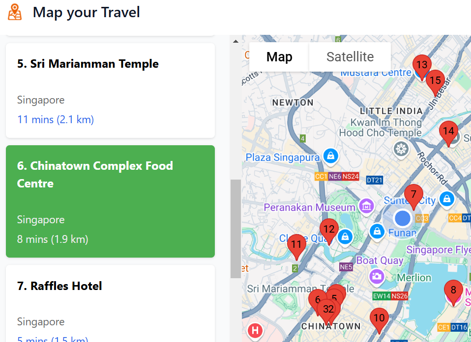
Map Your Travel
Map travel places on any webpage onto Google Maps
5
Problem
When readers look up food blogs or travel forums, they traditionally have to manually search each mentioned location on Google Maps, which is time-consuming and inefficient.
manually search each mentioned location on Google Maps
Solution
This is a browser extension that can identify and map every mentioned location, such as restaurants, onto Google Maps.
identify and map every mentioned location
Customers
Travel bloggers, food enthusiasts, and frequent travelers looking for a more efficient way to plan and execute their travel itineraries.
They are typically between the ages of 25-45 and frequently use online resources to plan trips and dining experiences.
Alternatives
View all Map Your Travel alternatives →
Unique Features
The extension instantly maps numerous locations from any webpage onto Google Maps, saving users time.
Includes travel times and distances between multiple points, enhancing route planning.
User Comments
Users appreciate the ease of use and time saved.
Some mention it enhances their travel planning experience.
A few comments suggest minor improvements for better user experience.
Users find it particularly useful for large cities with numerous dining options.
A small fraction of users mentioned occasional bugs.
Traction
Newly launched.
Featured on ProductHunt with increasing interest.
Market Size
The global travel technology market was valued at approximately $13.6 billion in 2022, with a continued growth trend as digital solutions for travel planning become more sought after.